Paper to be presented at the annual meeting of the American Sociological Association session on "Before the Flood: PreColumbian World-Systems in the Americas."
Draft v. 6-24-99. Comments and corrections welcome.
Table of Contents
Comparing World-Systems
Spatial Boundaries
Core/Periphery Relations
World-System Cycles
Pulsation
Rise and Fall
The Chesapeake in the Time of Captain Smith
Bounding the Chesapeake
Interaction Nets
The Bulk Goods Net
The Prestige Goods Networks
The Political/Military Net
Ethnogeography
Core/Periphery Relations
Eleven Millennia on the Chesapeake
Paleoindians
Early and Middle Archaic
Late and Terminal Archaic
Early Woodland and the
Chesapeake Adena
The Middle Woodland
The Late Woodland
Rhyolite Fall-off from
Paleoindian to Late Woodland
The Chesapeake in Comparative and Macroregional
Perspective
Interaction Nets Over
the Long Run
Pulsation, Rise and
Fall
Interaction and Evolution on the Chesapeake
This paper provides a brief overview of the comparative world-systems approach and explicates our concepts of "pulsation" and "rise and fall." It then paints a synchronic portrait of the structures of the world-system of the Chesapeake in 1608 and examines the phenomena of pulsations and rise and fall in the previous eleven millennia in comparative perspective. Why was the Chesapeake influenced by development in adjacent regions during some periods but not others? Was the Chesapeake a periphery of the Mississippian world-system? Why did maize cultivation come into the Chesapeake so late, and why did its adoption correspond with a decrease in societal complexity and hierarchy? These are the questions we are asking.World-systems ideas have been widely applied to premodern systems and the relevant literature on North America before the coming of the Europeans has grown in recent years (e.g. Nassaney and Sassaman 1995; Peregrine and Feinman1996; Chase-Dunn and Hall 1997; Chase-Dunn and Mann 1998). This paper focuses on the Chesapeake region in order to comprehend both its uniquenesses and its relevance to questions posed by the comparative world-systems approach.
The world-systems perspective emerged as a theoretical approach for modeling and interpreting the expansion and deepening of the European system as it engulfed the globe over the past 500 years (Wallerstein 1974; Chase-Dunn 1998; Arrighi 1994). The idea of a core/periphery hierarchy composed of "advanced" economically developed and powerful states dominating and exploiting "less developed" peripheral regions has been a central concept in the world-systems perspective. In the last decade the world-systems approach has been extended to the analysis of earlier and smaller intersocietal systems. Andre Gunder Frank and Barry Gills (1993) have argued that the contemporary world system is a continuation of a 5000-year old system that emerged with the first states in Mesopotamia. Chase-Dunn and Hall (1997) have modified the basic world-systems concepts to make them useful for a comparative study of very different kinds of systems. We include very small intergroup networks composed of sedentary foragers, as well as larger systems containing chiefdoms, early states, agrarian empires and the contemporary global political economy in our scope of comparison.
The comparative world-systems perspective is designed to be general enough to allow comparisons between quite different systems. We define world-systems as important networks of interaction that impinge upon a local society and condition social reproduction and social change. We note that different kinds of interaction often have distinct spatial characteristics and degrees of importance in different sorts of systems. We hold that the question of the nature and degree of systemic interaction between two locales is prior to the question of core/periphery relations. Indeed we make the existence of core/periphery relations an empirical question in each case, rather than an assumed characteristic of all world-systems.
Spatially bounding world-systems necessarily must proceed from a locale-centric beginning rather than from a whole-system focus. This is because all human societies, even nomadic hunter-gatherers, interact importantly with neighboring societies. Thus if we consider all indirect interactions to be of systemic importance (even very indirect ones) then there has been a single global world-system since humankind spread to all the continents. But we note that interaction networks, while they were always intersocietal, have not always been global in the sense that actions in one region had major and relatively quick effects on distant regions. When transportation and communications were over short distances the world-systems that affected people were small.
Thus we use the notion of "fall-off" of effects over space to bound the networks of interaction that importantly impinge upon any focal locale. The world-system of which any locality is a part includes those peoples whose actions in production, communication, warfare, alliance and trade have a large and interactive impact on that locality. It is also important to distinguish between endogenous systemic interaction processes and exogenous impacts that may importantly change a system but are not part of that system. So maize diffused from Mesoamerica to Eastern North America, but that need not mean that the two areas were part of the same world-system. Or a virulent microparasite might contact a population with no developed immunity and ravage that population. But such an event does not necessarily mean that the region from which the microparasite came and the region it penetrated are parts of a single interactive system. Interactions must be two-way and regularized to be systemic. One shot deals do not a system make.
We note that in most intersocietal systems there are several important networks of different spatial scales that impinge upon any particular locale:
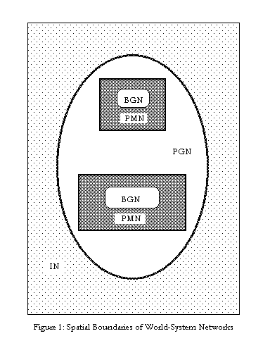
The first question for any focal locale is about the nature and spatial characteristics of its links with the above four interaction nets. This is prior to any consideration of core/periphery position because one region must be linked to another by systemic interaction in order for consideration of core/periphery relations to be relevant.
The spatial characteristics of these networks clearly depend on many things - the costs of transportation and communications, and whether or not interaction is only with neighbors or there are regularized long-distance trips being made. But these factors affect all kinds of interaction and so the relative size of networks are expected to approximate what is shown in Figure 1. As an educated guess we would suppose that fall-off in the PMN generally occurs after two or three indirect links. Suppose group A is fighting and allying with its immediate neighbors and with the immediate neighbors of its neighbors. So its direct links extend to the neighbors of the neighbors. But how many indirect links will involve actions that will importantly affect this original group? It is our guess that the number of indirect links that bound a PMN are either two or three. As polities get larger and interactions occur over greater distances each indirect link extends much farther across space. But the point of important fall-off will usually be after either two or three indirect links.
We divide the conceptualization of core/periphery relations into two analytically separate aspects:
Using this conceptual apparatus we can construct spatio-temporal chronographs for how the social structures and interaction nets of the human population changed their spatial scales to eventuate in the single global political economy of today. In Chase-Dunn and Hall (1997: 203) Figure 10.1 uses PMNs as the unit of analysis to show how a "Central" PMN composed of the merging of the Mesopotamian and Egyptian PMNs in about 1500 BCE eventually incorporated all the other PMNs into itself.
World-system Cycles: Rise-and-Fall and Pulsations
Comparative study reveals that all world-systems exhibit cyclical processes of change. We focus here on two major cyclical phenomena: the rise and fall of large polities, and pulsations in the spatial extent and intensity of trade networks. What we call "rise and fall" corresponds to changes in the centralization of political/military power in a set of polities. It is a question of the relative size of and distribution of power across a set of interacting polities. The term "cycling" has been used to describe this phenomenon as it operates among chiefdoms (Anderson 1994 and below).
We note that all world-systems in which there are hierarchical polities experience a cycle in which relatively larger polities grow in power and size and then decline. This applies to interchiefdom systems as well as interstate systems, to systems composed of empires, and to the modern rise and fall of hegemonic core powers (e.g. Britain and the United States). Though very egalitarian and small scale systems such as the sedentary foragers of Northern California (Chase-Dunn and Mann, 1998) do not display a cycle of rise and fall, they may experience other related sorts of cycle.
All systems, including even very small and egalitarian ones, exhibit cyclical expansions and contractions in the spatial extent and intensity of exchange networks. We call this sequence of trade expansion and contraction pulsation. Different kinds of trade (especially bulk goods trade vs. prestige goods trade) usually have different spatial characteristics. It is also possible that different sorts of trade exhibit different temporal sequences of expansion and contraction. It should be an empirical question in each case as to whether or not changes in the volume of exchange correspond to changes in its spatial extent.
The simplest hypothesis regarding the temporal relationships between rise-and-fall and pulsation is that they occur in tandem. Whether or not this is so, and how it might differ in distinct types of world-systems, is a set of problems that are amenable to empirical research.
In earlier work we have presented evidence regarding the answer to some of these questions. We have contended that the causal processes of rise and fall differ depending on the predominant mode of accumulation. One big difference between the rise and fall of empires and the rise and fall of modern hegemons is in the degree of centralization achieved within the core. Tributary systems alternate back and forth between a structure of multiple and competing core states on the one hand and core-wide (or nearly core-wide) empires on the other. The modern interstate system experiences the rise and fall of hegemons, but these never take over the other core states to form a core-wide empire. This is the case because modern hegemons are pursuing a capitalist, rather than a tributary form of accumulation.
Analogously rise and fall works somewhat differently in interchiefdom systems because the institutions that facilitate the extraction of resources from distant groups are less fully developed in chiefdom systems. David G. Anderson's (1994) study of the rise and fall of Mississippian chiefdoms in the Savannah River valley provides an excellent and comprehensive review of the anthropological and sociological literature about what Anderson calls "cycling," the processes by which a chiefly polity extended control over adjacent chiefdoms and erected a two-tiered hierarchy of administration over the tops of local communities. At a later point these regionally-centralized chiefly polities disintegrated back toward a system of smaller and less hierarchical polities.
Chiefs relied more completely on hierarchical kinship relations, control of ritual hierarchies, and control of prestige goods imports than do the rulers of true states. These chiefly techniques of power are all highly dependent on normative integration and ideological consensus. States developed specialized organizations for extracting resources that chiefdoms lacked -- standing armies and bureaucracies. And states and empires in the tributary world-systems were more dependent on the projection of armed force over great distances than modern hegemonic core states have been. The development of commodity production and mechanisms of financial control, as well as further development of bureaucratic techniques of power, have allowed modern hegemons to extract resources from far-away places with much less overhead cost.
The development of techniques of power have made core/periphery relations ever more important for competition among core powers and have altered the way in which the rise-and-fall process works in other respects.
We have argued that population growth in interaction with the environment, and changes in productive technology and social structure produce social evolution that is marked by cycles and periodic jumps (Chase-Dunn and Hall 1997:Chapter 6). This is because any world-system varies around an equilibrium or mean due both to internal instabilities and environmental fluctuations. Occasionally, on one of the upswings a system solves its problems in a new way that allows substantial expansion. We want to explain expansions, evolutionary changes in system logic, and collapses. That is the point of comparing world-systems.
The plan of this paper is to present a synchronic portrayal of the Chesapeake system in the early seventeenth century and then to explore the processes of rise and fall and pulsation that led up to that consequence. Multiscalar spatial analysis has recently been advocated and applied to the Southeast and the Midwest by the studies contained in Nassaney and Sassaman (1995). Decisions about the importance of diffusion, migration and in situ development should not be a matter of the predilections of lumpers or splitters. In each case we need to examine the evidence to decide what happened. Nassaney and Sassaman also recommend a multiscalar temporal analysis that compehends short-run, middle-run and the longue duree in a single comparative framework. This is the approach that we wish to apply to the Chesapeake.
The Chesapeake System in the Time of Captain Smith
Captain John Smith's reconnaissance of the Chesapeake
Bay in 1607 and 1608 and his detailed map provide a window on the indigenous
world-system before it was massively disrupted by the coming of Europeans.
Smith knew the Powhatan dialect of Algonquian and his geopolitical strategies
made him pay close attention to the niceties of alliances and enmities
among the native groups that he encountered (Potter 1993:181). 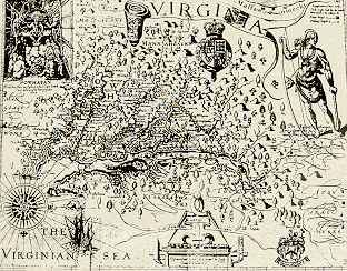
Figure 2: John Smith's map of the Chesapeake.
The literature on this region and period is huge and we have only been able to read some of it. The combination of documentary, linguistic and archaeological evidence has produced a fairly clear picture of the world-system of the Chesapeake in 1608 and this helps us to interpret the archaeological evidence from earlier periods.
The linguistic situation in the early sixteenth century had different dialects of the Eastern Algonquian language stock spoken on the entire Chesapeake (See Figure 3). The Algonquian-speaking peoples may have migrated from the Great Lakes region in a number of waves over the past two millennia (Potter 1993:3) To the west in the piedmont of the Blue Ridge mountains were groups of Souixan speakers (the Monacans and the Mannahoacs) and on the Susquehanna River at the northern end of the Chesapeake Bay there were the Iroquoian-speaking Susquehannocks. Another group of Iroquoian-speaking people, the Massawomecks, were raiding and trading into the Chesapeake from a homeland somewhere to the northwest (Pendergast 1991). To the south of the Chesapeake there were Algonquin speakers near the coast (Chawanoc, Weapemeoc and Roanoke) and southern Iroquoian speakers near the fall line between the coastal plain and the piedmont terrain (Nottoway, Meherrin and Tuscarora). Thus there were three major language stocks, each with several dialects, and many of the dialects were mutually unintelligible.
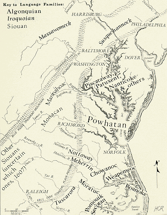
Figure 3: Language stocks and dialects in the Chesapeake region circa 1607 (Rountree 1993a: frontispiece).
Bounding the Chesapeake Interaction Networks
This is a rough effort to determine the nature and scale of the interaction networks of the Chesapeake world-system based on the descriptions found in the published literature. A more thorough study would code reports of interaction events from the documentary literature and utilize linguistic and archaeological evidence to test hypotheses about interaction densities, ranges and fall-off (e.g. Chase-Dunn and Mann 1998).
As we have mentioned above, the bounding of world-systems requires that we begin at some point in space. The obvious choice, because of evidence and structure, is to put the Powhatan paramount chiefdom in the center and to survey the interaction networks and core/periphery relations from this vantage point.
The Powhatan chiefdom is named after the individual (also called Wahunsenacawh) who held the position of paramount chief (mamanatowick) over about thirty smaller chiefdoms or districts, each with its own "werowance," or chief. Powhatan's original home village was very near what is now Richmond, Virginia on the James River. Chief Powhatan had inherited control of nine small districts on the upper portions of the James and York Rivers. In the last years of the sixteenth century he initiated a series of campaigns of expansion by conquest which successfully extended his control over all the districts on the lower James and York Rivers as well as the south end of the Chesapeake Bay. The Powhatan paramountcy also induced tribute payments from districts on the Rappahannock and Potomac Rivers and across the bay (what is now Virginia's Eastern Shore).
Just north of the Powhatan paramountcy was another large polity on the north shore of the tidewater Potomac River just below what is now the District of Columbia, the so-called Conoy paramount chiefdom, whose paramount chief ("tayac") was a Piscataway. The smaller chiefdoms of the Patuxent River were not part of the Conoy paramountcy, and neither were the groups along the southern shore of the tidewater Potomac. The Conoy paramountcy probably emerged by about 1500 as the first large chiefly polity of the protohistoric period. By the time of Captain Smith it had already begun to decline with the secession of the Patowomeke (Potter 1993:150). Here is a Chesapeake instance of rise and fall, or at least rise and decline.
The Bulk Goods Networks
The bulk goods network (BGN) was composed of a local subsistence net in which commoner families produced most of their own food by means of hunting, fishing, gathering and horticulture, and a larger political economy of tribute in which local chiefs collected from their own commoners and passed food and other valuables on to regional paramounts. Corn was transported across the Chesapeake from Eastern Shore chiefdoms tributary to Powhatan. Commoners stored food in concealed household storage pits while chiefs displayed their wealth in granaries and store-houses (Potter 1993:172).
The subsistence of the Powhatan and surrounding groups was based on horticulture supplemented by hunting and gathering. It is estimated that over 50% of the food consumed was maize (Potter 1993: 40). Other crops were beans, squash, pumpkins, gourds, sunflowers and tobacco. Deer hunting was done mainly in the winter in upland regions. Deer were scarce in the heavily populated riverine and estuarine regions. But shellfish and other marine resources were an important part of the diet. The political economy was primarily one in which matrilineal families supplied there own needs, but there was an important overarching structure of accumulation.
Class formation had emerged in these societies such that there was an important degree of inequality between chiefs and commoners. Chiefs were understood to be a special and powerful group with claims on the labor and produce of commoners. The holders of chiefly offices were served by priests and by war leaders chosen from the commoners. Local chiefs collected food and other valuables and then paid tribute to paramount chiefs. The collected goods were stored in special mortuary temples (see Figure 4) that also served as storehouses containing maize, animal skins, copper, beads, pearls and dyes. Only priests and werowances were allowed to enter these temples. These valuables were used by chiefs and paramounts to reward subalterns and for trade.
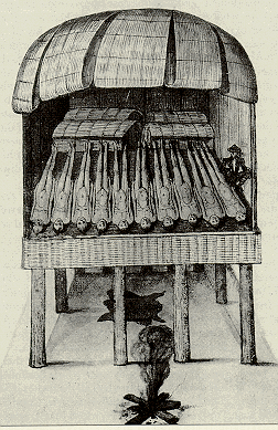
Figure 4. North Carolina Mortuary temple/store house. [Water color by John White about 1585. Chesapeake Algonquian chiefdoms had similar structures.]
The Prestige Goods Networks (PGNs)
Prestige goods moved locally and over great distances by means of both trade and direct procurement. The amount of long-distance trade was less than had been the case a few hundred years earlier, before the adoption of horticulture and the most recent rise of the chiefdoms. Antimony, a silvery substance used for body paint, was mined near the head of Aquia Creek in the territory of the Patowomeke, an important chiefdom on the south shore of the tidewater Potomac. Antimony paint was observed in use on the south bank of the James River and was considered a luxury item by the Powhatans. Potter(1993:161) contends that control of this valuable mineral enhanced the power of the Patowomeke werowance. Marine shells from the Atlantic, copper from the Blue Ridge and from the Great Lakes region, puccoon ( a red pigment used to dye the skin) from the southern piedmont, and pearls (probably from the north) were all important prestige goods in the Powhatan and Conoy paramountcies (see Figure 5).
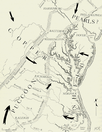
Figure 5: Luxury goods entering the Chesapeake in 1608 (Rountree 1993a: 221)
The scale of the PGN was not uniform regarding different luxury goods. Some of the copper came from the Great Lakes while shells and shell beads came from the Eastern Shore. There are important questions regarding the form and institutional nature of exchange in this system. Obviously copper merchants were not travelling from Lake Superior to the Chesapeake to sell their wares. Copper must have been traded down-the-line, passing from group to group. And all the other goods could have also been traded in this manner in the absence of long-distance trading missions. But Rountree (1993b) contends that traders and travelers did make long journeys, and she cites accounts from the historical period about institutions of hospitality for travelers. Of course the transportation situation changed greatly in the historic period, so these instances may not accurately reflect the prehistoric situation. The rather high level of warfare in this region (see below) would have made long-distance trade journeys quite risky.
Regarding the institutional nature of exchange, there is little discussion in the published literature. We know that some luxury goods and corn were accumulated as tribute by paramount chiefs and that gifts were given in order to secure military alliances among chiefdoms. There is little discussion of the existence of standardized media of exchange (money), and yet shell beads and copper were used to purchase goods. Apparently most of the disk-shaped shell bead strings used in trade, called "roanoke," were manufactured at Cuscarawaoke, a village on the Eastern Shore that was outside of the Powhatan realm (Turner 1993:83). Roanoke was taken on trade missions and used to purchase other goods. But was it a standardized medium such that rates of exchange (prices) were known and important features of trade? Davidson says, "Smith and other early English visitors to the Chesapeake region considered roanoke and peak to be types of Indian 'money,' and these beads were commonly used as currency by both the Indians and the English later in the seventeenth century." (1993:145)
Another question is about who the traders were. In many stateless world-systems only chiefs engaged in trade. But there seem to have been instances in the early historic Chesapeake in which commoners engaged in trade with the English. Did commoners also engage in certain kinds of trade in the prehistoric indigenous system?
The Political/Military Network
The political/military network (PMN) was an interchiefdom system in which each small chiefdom held a fixed territory with known boundaries. The best succinct description comes from Potter:
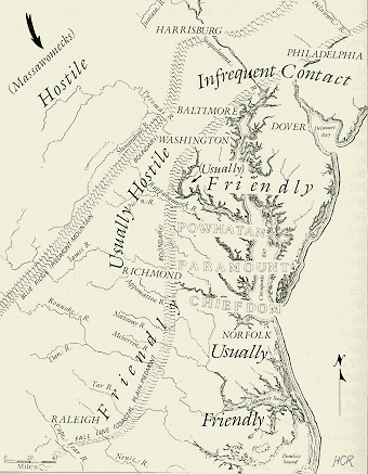
Figure 6: Political/military and trade relations of the Powhatans circa 1608 (Rountree 1993c: 214)
The settlement system was composed of small hamlets and larger villages distinguished by the residence of a chief and usually a nearby mortuary/storehouse temple. Villages varied in size from two to fifty houses, with from six to twenty residents in each house (Potter 1993: 23; 27). Most of the villages had houses and other features spread over a large area of the sort illustrated in Figure 7.
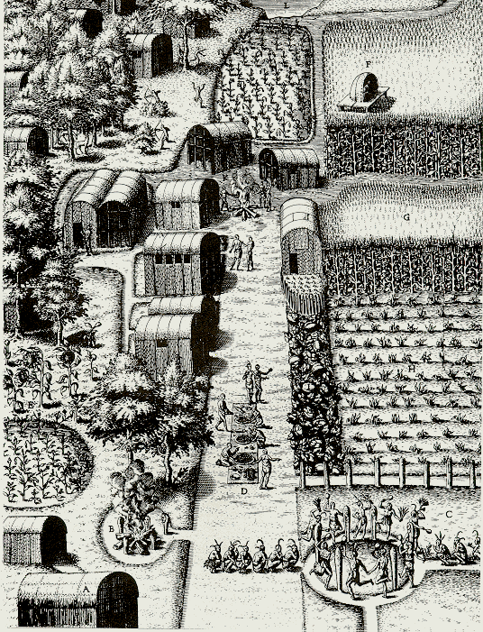
Figure 7: John White's drawing of Secoton, North Carolina. The Virginia Algonquian villages are thought to have been quite similar.
On the other hand, there were also palisaded villages in which the houses and other features were crowded close together and enclosed in a defensive wall of stakes set into the ground (see Figure 8). These palisaded villages were a recent development and they tended to be either important political centers containing chiefs' houses and temple/mortuaries or else to be located along conflictive territorial boundaries.
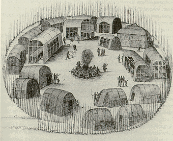
Figure 8: North Carolina Algonquian palisaded village similar to those known historically and archaeologically on the Chesapeake.
Some of the polities had not yet adopted chiefdom level organization. The Chickahominies, near the heartland of the Powhatan paramountcy, were governed by a council of elders and refused to accept a chief appointed by Powhatan (Potter 1993:170).
Beyond the matrilineal inheritance of chiefships, not much is known about Chesapeake Algonquin kinship. This is unfortunate because chiefdom formation is a process of reorganizing kin relations to create social classes and to delineate claims to social authority based on hierarchized kinship. Kinship can facilitate or undercut the power of leaders depending on how it is structured and it would be nice to know more about how the different Algonquian speakers reckoned blood relations.
Potter (1993:211-213) contends that mortuary customs for deceased chiefs and priests were quite different from those for commoners. He also quotes John Smith about Algonquian beliefs regarding the afterlife. Chiefs and priests go beyond the mountains and the setting sun and dance and sing forever. And Smith says, " But the common people they suppose shall not live after death" (quoted in Potter 1993:213). This implies a rather radical differentiation between the chiefly class and the commoners, though it is unknown whether or not the commoners also held these beliefs. An additional element that indicates a substantial degree of inequality in Chesapeake societies is the institution of polygyny. Many egalitarian societies have polygyny in which the head man has more than one wife, perhaps two or three or four. Chief Powhatan reportedly had over 100 wives (Potter 1993: 17).
And yet Rountree (1993a:7-13) argues strongly that the power of the paramount was greatly limited with regard to control over the actions and attitudes of commoners and district chiefs within the paramountcy. She gives many examples that illustrate a good degree of autonomy from the will of the paramount. It would also appear that authority was largely charismatic rather than bureaucratic. Opechanecough, a younger brother of Powhatan, was the effective leader for many years after Powhatan died despite that his older brother Opitchapam officially held the position of paramount (Potter 1993:185).
A key question for class formation is about the control of necessary resources such as land, water, mines, fishing places, hunting grounds and etc. In complex chiefdoms with severe class structures the commoners have been separated from legitimate claims over necessaries and must rely on chiefs. In simple chiefdoms the chiefly class often tries to legitimate the accumulation of surplus product from commoners by monopolizing the importation of symbolic goods held necessary for social reproduction, marriage, etc. or by promoting an ideology in which the chiefs ritually intervene with powerful forces of the universe. It is most likely that the Algonquian chiefdoms were of this latter sort.
So two rather large paramountcies, the Powhatan and the Conoy, were surrounded mainly by rather more autonomous district chiefdoms and less hierarchical polities. According to Hantman (1993) both the Monacans and the Mannahoacs had multidistrict polities in which several districts paid tribute to one. Clark and Rountree (1993) describe the organizational differences between the more centralized Conoy paramountcy and the confederation of district chiefdoms on the Patuxent River. According to Potter "The people of the chiefdoms were more sedentary than their more egalitarian neighbors and the settlements were usually smaller, but there were more of them and they were closer together "(1993:170).
The Souixan-speaking Monacans and Mannahoacs in the piedmont to the west of the Powhatan were his traditional enemies and a wide uninhabited buffer zone separated the Algonquians from the Souixans. Hantman has shown that the Monacans and Mannahoacs were maize agriculturalists who probably inhabited large villages and had multivillage polities. They were not nomadic hunter-gatherers as had been earlier surmised. Thus there was no radical valley people/hill people core/periphery differentiation in the seventeenth century. There were also smaller uninhabited buffer zones between the districts of Algonquian-speakers (see Figure 9).
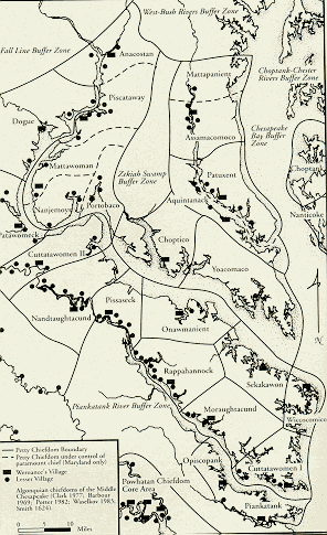
Figure 9: Map of Maryland and Northern Virginia Algonquians showing estimated chiefdom boundaries (Rountree 1993: 114).
Anthropologists have disputed whether these uninhabited zones were neutral deer parks (Turner 1978) or were no-mans-lands between conflicting groups (Mouer 1986). Based on the reports of Smith's reconnaissance it is agreed that the entire northwestern portion of the Chesapeake Bay, including the Magothy, Patapsco and Bush Rivers, were uninhabited in 1608. Smith's map indicates by the mark of a cross that he ascended the Patapsco (which he named the "Bolus") past what is now Baltimore and he reported seeing no indigenes or villages (See Figure 10). Both archaeologists and ethnohistorians contend that the northwest Chesapeake was a vast buffer zone that was abandoned about 1500, probably by Algonquian-speakers who were escaping the predations of invading Iroquoians (Susquehannocks and Massawomecks) from the west and north.
Figure 10: Detail from John Smith's map of Chesapeake showing the Patapsco River (Bolus flu).
All scholars agree that the Chesapeake system before the arrival of the Europeans was already experiencing a rather high level of warfare. Potter (1993:147) contends that warfare had increased after 1400 and became endemic after 1500. Most observers also point out that the level of warfare among indigenous groups increased to an even higher level with the arrival of the Europeans as groups contended against one another to control the influx of trade goods and to make alliances with different European factions. But the indigenous system was already quite warlike. We have mentioned the existence of buffer zones, depopulated regions and palisaded villages. Another indicator is the institution of the "huskenaw," a warrior initiation rite for adolescent boys (except priests) who were trained to endure torture and to fight. The institutional channeling and intensification of aggressive male identity is a known aspect of societal adaptation to high levels of warfare.
Regarding the spatial scale of the Powhatan PMN, we generally surmise that important political/military interaction includes two or at most three indirect interactions. The direct interactions displayed in Figure 6 above do not extend beyond the Blue Ridge mountains to the west, nor above the Susquehanna River to the north. But to the northwest, we have the mysterious Massawomecks. Much ink has been used on the question of the identity and homeland of these raiders and traders who came into the Chesapeake in birchbark canoes. In a most thorough review of the evidence Pendergast (1991) concludes that the Massawomecks were a contingent of the Iroquois confederation who originally inhabited the Niagara River valley near Lake Erie and who moved south in protohistoric times driven by indigenous conflict and the desire to control European trade goods. Pendergast has the later Massawomeck homeland at the headwaters of the Potomac River or thereabouts.
It is not clear whether the long-distance movements of the Massawomecks should be considered a typical feature of the indigenous PMN, or to what extent these journeys were stimulated by the arrival of the French in the St. Lawrence Valley. The literature on incorporation into the modern world-system and incorporation processes in earlier systems shows that when a state-based system begins to engulf a stateless one the amount of warfare in the "tribal zone" goes up (Ferguson and Whitehead 1992). Potter (1993) casts doubt on Pendergast's claim that the Massawomecks were motivated to move into the Chesapeake because of a desire to control access to European goods. Potter does not find archaeological evidence of European goods in the protohistoric Chesapeake. But information does not show up archaeologically. The Chesapeake appears on a Spanish map as early as 1527. It is not impossible that knowledge of European contact in the Chesapeake could have been a factor in the Massawomeck forays, but we agree with Potter that it is unlikely. If the Massawomeck were mainly run out by losing a struggle on Lake Erie and irrupted into the Chesapeake because of this, this would perhaps be an instance of one world-system impinging on another, but not an example of regularized interaction. We think the best guess about the Powhatan PMN's spatial extent is about a 300 mile radius from the Virginia tidewater.
Ethnogeography
The comparative world-systems perspective is also concerned with information flows (INs) and the cosmography of peoples. Information can flow across cultural and linguistic boundaries, and it may or may not accompany trade goods. Information fall-off is usually rather rapid in trade network organized as down-the-line trade. And in a situation of endemic warfare we can imagine not only barriers to information flows, but also the probability of disinformation. In a geopolitically complex situation actors may want to represent themselves as allies by telling lies about their relations with other players. John Smith did this when he traded with the Massawomecks and then displayed the received goods as prizes taken in battle to the Chesapeake Algonquians. This tactic may have also been employed in indigenous "diplomacy."
Regarding cosmography (ethnogeography) , Helen Rountree (1993b) has argued that Chesapeake indigenes probably knew more about distant places than they were letting on to Europeans. John Smith's map portrays a saltwater sea beyond the Blue Ridge Mountains on the shores of which are the four villages of the Massawomecks. Was this a misunderstanding spurred by English wishfulness regarding the "northwest passage" to the Orient, or was Powhatan really quite ignorant about the territory beyond the mountains? Smith also reports that the Tockwoghs, Algonquian-speakers at the north end of the Chesapeake, had little knowledge of the Powhatan at the south end of the Bay. If this is so, the scale of the information network would be less than 200 miles, at least in the north-south direction. Rountree (1993b:22) reports that one Tockwogh spoke the Powhatan dialect, but her map (Rountree 1993c: 214) designates Powhatan relations with the north end of the bay in terms of "infrequent relations" (See Figure 6 above).
Core/Periphery Relations
Were there core/periphery relations in the Chesapeake system? The comparative world-systems approach treats the issue of core/periphery structures as a problematic. We do not assume them. Earlier research has shown that state-based systems all have core/periphery structures and very egalitarian systems of sedentary foragers have only mild ones (e.g. Chase-Dunn and Mann 1998). This makes world-systems composed of chiefdoms important, because it was in these that core/periphery relations first emerged and became central to uneven development and institutional evolution.
Recall that there are two analytically separable aspects of core/periphery relations. The first, core/periphery differentiation, refers to a situation in which societies at different levels of complexity and internal hierarchy are interacting regularly and importantly with one another. The second, core/periphery hierarchy, refers to a situation in which one or more societies are exploiting and/or dominating other societies.
In practice core/periphery differentiation usually involves not only differences in complexity and hierarchy, but also differences in population density and modes of subsistence. In the Chesapeake in 1608 we find paramount chiefdoms interacting with simple chiefdoms and these interacting with egalitarian tribal societies. We also find important differences in the size and concentration of settlements that are probably related to important differences in social organization. We have already mentioned the somewhat unusual situation described by Potter in which core areas with chiefdoms had slightly smaller villages that were closer together, while non-core neighbors had larger villages but more spaced out.
The most relevant overview of the entire range of organizational diversity is Custer's survey of the MidAtlantic, which includes the Chesapeake and the Delaware and Susquehanna Rivers. Custer notes that the Lenape on the Delaware River never adopted maize planting and they remained at a band level of organization until contact. These were the last foragers in the region. But other groups differed greatly in the extent to which they had become involved in maize planting. The Munsee were planting maize, but it was not a large component of their mode of subsistence. Custer makes several important distinctions regarding the continua of complexity and hierarchy. He distinguished between bands and tribes. Tribes have pan-tribal sodalities, meaning kinship or other organizational categories that extend beyond the local group. Custer mentions age grades, clans, lineages and secret societies. Bands do not have these features of intergroup social structure. Custer also distinguished two different kinds of tribes: cognatic and lineal. Cognatic tribes have intergroup relations but these are weak and do not promote intergroup economic cooperation. Segmental tribes have kinship structures that sustain obligations among kin groups when growing villages hive-off. The lineage or clan then remains an important family tie in an intervillage cooperation network. Custer points out that this segmented tribal organization is most likely to develop in coarse-grained ecological situations that encourage exchange between different groups because of access to different kinds of natural resources. Custer contends that segmented lineage tribes are indicated in the archaeological record by longhouses in which extended families reside, whereas the people of cognatic tribes are more likely to live in smaller houses for nuclear families. Custer's typology of hierarchical organization also includes simple and complex chiefdoms.
One key advantage in a system in which warfare is an important institutional form of competition is population density, because the ability to concentrate a greater number of warriors is crucial in a confrontation. Most of the groups living around the Chesapeake had adopted horticulture in the Late Woodland period so there was not an important core/periphery differentiation based on interactions between farmers and foragers. But there were important differences among groups with regard to the degree of internal hierarchy and the nature of central authority. This is an important aspect of core/periphery differentiation.
Turner (1993) contends that the core area of the Powhatan paramountcy was the population dense territory of the Pamunkey chiefdom (at the confluence of the Pamunkey and Mattoponi branches of the York River). The Pamunkeys had a long-standing rivalry with the Chickahominies, also a powerful and population dense core polity (See Figure 11). This rivalry and the strategic importance of the home district of Powhatan at the James River fall line with regard to trade routes and protection from the piedmont Souixans, led to the formation of an alliance between Powhatan and Pamunkey which was the basis of Powhatan expansion ( Turner 1993:86;90-92).
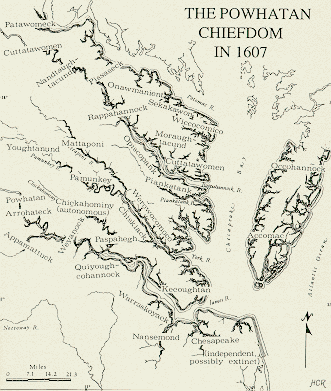
Figure 11: The district chiefdoms in the Powhatan paramountcy in 1607 (Rountree 1993a: 77).
If Turner is right this sounds like a possible instance of semiperipheral development, a phenomenon known mostly from state-based world-systems. Polities from semiperipheral regions are often able to take over older cores and to implement changes in the scale of polities and institutional structures. Semiperipheral marcher chiefdoms are known from Polynesia (Kirch 1984: 199-202) and elsewhere (Chase-Dunn and Hall 1997: 83-4). The phenomenon of cycling, in which interchiefdom systems experience the rise of larger and more hierarchical polities, and then these collapse back into smaller chiefdoms, has already been mention above. It may be that the rise phase of the cycle is often due to the action of semiperipheral chiefly polities, and that the Powhatans were an example of this phenomenon.
The most obvious instance of core/periphery hierarchy in the Chesapeake was the tribute extraction by paramount chiefs from local districts. This was core/periphery exploitation and unequal exchange. Most Powhatan scholars are quick to point out that it is a mistake to characterize the tribute system as "redistribution" because very little was redistributed to the original contributors. But as Davidson (1993) points out, it is often difficult to distinguish tribute-paying from exchange in interchiefdom systems. The contemporary accounts of corn and shell beads being brought in canoes from the Eastern Shore as tribute to Powhatan may not have represented exploitation if an equal value of goods was being returned. Davidson contends that this "tribute" was simply the continuation of a long tradition of east-west exchange across the bay. He supposes that the chiefdoms of the Eastern Shore would have been difficult for Powhatan exploit because of the difficulties of projecting coercion so far.
There are a number of considerations here. Unequal exchange can take place in the absence of direct coercion if peripheral agents can be induced to exercise their own coercion over others in order to obtain core goods. An example is the slave trade in the Pacific Northwest (Chase-Dunn and Hall 1998). It is possible that Eastern Shore chiefs were so desirous of copper or puccoon supplied by Powhatan that they were willing to extract beads and/or corn from their own people in order to obtain these valuables. It is also possible that Davidson is wrong about the spatial extent of the power capabilities of Powhatan. Canoes full of warriors may have been quite capable of threatening villages across the bay.
Davidson also points out that the Conoy paramountcy had similar relations with those Eastern Shore groups north of those that were linked with Powhatan. This case is also problematic with regard to the question of core/periphery hierarchy. In 1660 the brother of the Piscataway tayac testified that thirteen reigns earlier the Conoy had been led by a chief from the Eastern Shore whose name was Uttapoingassinem (Potter 1993:132). It is possible that a peripheral chief peacefully became the paramount of a regional core, but not likely. More likely is that an important Conoy chiefess married an Eastern shore chief and he moved to Maryland and rose to the top. If this is what happened it would support the hypothesis of Davidson that the east-west interaction was between societies of equal power.
It is likely that most core/periphery exploitation and domination was rather local in the Chesapeake system. The paramountcies did not sufficiently control trade valuables, or produce great quantities of surplus food to make unequal exchange with distant regions possible. Nor were they able to project military power very far. Despite a rather high level of warfare among different groups, there were no conquest-based polities that were very large. The Powhatan expansion had probably gone about as far as it could go.
Eleven Millennia on the Chesapeake
The general model of social evolution that has been applied to North America, as elsewhere, is that groups migrated to fill the land, then population increased, and trade, complexity and hierarchy emerged. The common picture is one of increasing population density and the development of more complex societies in each region and increasing trade within and between regions. But this general model becomes more complicated when we look more closely. The overall trends toward greater population density, complexity and trade are broken by cyclical processes of rise and fall, changes in the patterns of interaction within and between regions and uneven develop with regard to time a space.
Paleoindians
Humans may have first arrived in the Chesapeake region around 11,000 years ago. Archaeologists delineate the Paleoindian period from 9,500 BC to 8,000 BC. The first pioneers of the Chesapeake were small nomadic groups of big game hunters who helped to extinguish the remaining MidAtlantic Pleistocene megafauna (e.g. mammoths, mastodons, caribou, moose, bison and musk-ox) at the end of the last ice age. The early Paleoindians are known archaeologically mainly by their lanceloate fluted Clovis-style spear points, usually made from exotic lithic materials in shapes that are quite similar across all of North America. During the Wisconsin ice age glaciers extended into northern Pennsylvania and northern New Jersey. Because the sea level was much lower, most of what is now the broad Chesapeake Bay was instead narrow rivers and streams and what is now the ocean shelf was exposed. Many riverside and shoreside Paleoindian camps were inundated as the water rose over the millennia. The early Paleoindians wandered freely over large areas pursuing megafauna. These small bands probably encountered other bands infrequently, but they must have had arrangements to come together seasonally in order to exchange marriage partners. It is thought that these small bands exchanged stone materials and other valuables when they met one another, but many of the exotic lithics may have been obtained by direct procurement during the wide-ranging movements of these nomadic hunters.
It is difficult to conceptualize world-systems completely inhabited by nomads because territoriality is such an important feature of most world-systems. Once sedentary societies have emerged there is an extremely important interaction between sedentary and nomadic societies that begs for analysis with world-systems concepts (Hall 1991). The paleolithic and subsequent periods are particularly fascinating because it was in these times that the cultural institutions of territoriality were first invented.
While a few isolated Paleoindian spear points are found all over the Chesapeake region, the most important known habitation site is the Flint Run complex on the south branch of the Shenandoah River (Fagan 1991: 109-110). This site was adjacent to a jasper quarry and was a major manufacturing center where finished artifacts and tool blanks were produced. The Flint Run sites were utilized from 9500 BC to 6500 BC.
It is probably mistaken to assume the complete absence of territoriality even among the early paleolithic nomads. The processes of population pressure, migration and competition for territorial resources operated on these nomadic societies, especially in a situation in which a major food source, the Pleistocene megafauna, were disappearing. The fact that Paleoindians spread over the Americas in a rather short time shows that they were quick to migrate rather than to stay and defend territory from newly arriving groups. The dominant image of peaceful exchange among these small groups that allowed valuables to move thousands of miles by means of down-the-line exchange should not be read to mean a completely pacific relationship among groups. The question of who should stay and who should move on, especially from food-rich areas, was probably not settled by consensus. There is little archaeological indication of these conflicts, but they would have been only small scale encounters.
In the middle and late Paleoindian period new projectile point types developed that were more regionally differentiated than the Clovis points had been. Anderson (1995) interprets this as indicating a transition to bounded habitual base areas or settlement ranges and decreased mobility.
Early and Middle Archaic
The Early Archaic (8000-6000 BC) is represented in Chesapeake region by certain new kinds of projectile points. Their are indications of population growth, more habitation sites, a more diversified foraging including hunting of smaller game, fishing and more trade. In the Middle Archaic (6000-4000 BC) there are indications of increased decreasing nomadism. It is estimated that a "middle Atlantic macroband" occupied the region with about 8 or 10 smaller nomadic bands containing a total of from 500 to 1500 people who came together seasonally to exchange gifts and marriage partners (Fagan 1991:315).
There was increased trade of rhyolite, a dense and workable lithic material that is only found in quarries in a restricted area on the west side of the Catoctin Mountains (near Camp David in piedmont Maryland). Between a quarter and a third of the projectile points found at sites near the Chesapeake Bay were made of rhyolite in the Early and Middle Archaic. Rhyolite had long been used to make projectile points. Indeed several Paleoindian points that have been found on the Eastern Shore 150 miles from the Catoctin were made of rhyolite (see Table 1 below). The proportion of all points made of rhyolite increase greatly all over the Chesapeake region during the Early and Middle Archaic. This indicates the emergence of stable long distance trade relationships.
We also see the first beginnings of increased attention to ritualized burials. Archaeologists reason that ritualized burials in cemeteries appear when people start passing vital resources from one generation to the next through lineages and other kin organizations. The most likely resource is ancestral claims to territory. Here we have the beginnings of institutionalized territoriality, the symbolization of claims to place.
The Middle Archaic may have seen the emergence of an early core/periphery interaction system between more sedentary riverine and estuarine peoples and more nomadic hunter-gatherers living in the hills. Sassaman (1995) interprets evidence from the Southeastern Middle Archaic as indicating such a pattern.
Late and Terminal Archaic
The Late Archaic period in the Chesapeake is designated from 4000 to 1500 BC and the Terminal Archaic from 1500 to 1000 BC. During these periods there is evidence of increased usage of gathered vegetable materials such as acorns and more systematic fishing with harpoons and fish wiers. There is also the first emergence of mild social ranking, but long-distance exchange networks have declined somewhat as indicated by less use of rhyolite at sites distant from its source. Habitation sites are closer to rivers, indicating more intensive use of fishing. The greater occurrence of gouges and adzes suggests that dug-out canoes were being produced (Kavanagh 1982: 97). There is also increased use of heavy bowls and other objects carved of steatite (soapstone). This is deemed an indicator of increased sedentism.
Beginning near the end of the Late Archaic in the Chesapeake there was a development in the Mississippi Valley in Louisiana that presaged later events in the Mississippi and Ohio River valleys that would have relevance for the Chesapeake. This was the Poverty Point culture, a concentrated group of sedentary diversified foragers who constructed large ceremonial mound complexes and were central to long-distance trade networks.
Early Woodland and the Chesapeake Adena
The Early Woodland period in the Chesapeake is designated as from 1000 BC to 200 AD. The residents of the Chesapeake region began fashioning pots out of clay during this period. Trade, as indicated by the usage of rhyolite at places distant from its source, continued to decrease in the Early Woodland period.
In the river valleys of the midwest groups supplemented their hunted and gathered foods by the cultivation on a small scale of certain domestic plant species (Smith 1992). But in the Chesapeake there is no evidence of the cultivation of domesticated plants before the Late Woodland period (Potter 1993:109).
In the valley of the Ohio there emerged the Adena ceremonial complex that constructed elaborate mounds for the dead (Dragoo 1963). Early Adena burials contain mostly utilitarian objects, but later Adena mounds contain definite evidence of social hierarchy, probably big man systems, because of rich exotic goods contained in the elaborate and large-scale interments. Whereas the religion may have originated as a way of symbolizing the claims of egalitarian groups to territory, it appears that this led to the emergence of an elite that traded luxury goods over a wide area. The exchange networks were quite developed and there may have been long-distance trade missions carried out by religious specialists to obtain rare goods. At the same time local identities were becoming more important as indicated by the emergence of distinctive styles of propoints and pottery.
Of significance in the Chesapeake is the discovery of Adena residential and mortuary sites in Delaware (Custer 1984a), the Eastern Shore near Cambridge and Salisbury, Maryland (Bastian 1975) and on the West River on the western shore of the Chesapeake (Ford 1976). The Adena sites on the Delaware Bay emerged about 500 BC. These MidAtlantic sites are identified as Adena because of the presence of certain items that are known to be associated with the Adena religious complex, especially tubular Ohio pipestone pipes and short, thick-walled copper beads, but also elaborate burial mound complexes. These Adena big man societies were surrounded by the more egalitarian Early Woodland inhabitants of the Chesapeake region. This constituted an early instance of core/periphery differentiation between big man societies and neighboring more egalitarian societies.
It is not clear whether the Chesapeake Adena were immigrants from the West as claimed by Dragoo (1963) or whether indigenous groups had become converts to the Ohio religion through ritualized long-distance trade relationships (Custer 1984a). Custer(1984a: 113-130) reports many stylistic continuities between the Wolfe Neck complex and the Adena sites on the Delaware Bay that would indicate in situ adoption rather than immigrant intrusion. The long-distance trade networks had long involved the importation of goods such as copper from Lake Superior and etc. and so the presence of Adena goods might only signify trade. But the building of mortuary complexes in the Adena style indicates the presence of the religious ideology and customs of the Adena ceremonial complex. If it was in situ groups adopting a new religion from distant contacts we can wonder why these would have differentiated themselves from their neighbors in this way? Custer (1993) has argued that the Adena complex on the Delaware Bay emerged because of the circumscribed environmental richness of this coastal location. The same consideration would not seem to apply to the other Chesapeake Adena sites. While most were estuarine, the Nassawango Creek site near Salisbury, Maryland was riverine, about midway between the Chesapeake Bay and the Atlantic Ocean (Bastian 1975). It is hard to see how ecological circumscription could have determined the location of all these sites.
The Middle Woodland
In any case the Adena complex declined and disappeared in the Chesapeake by the last century BC, whereas in Illinois and Ohio a new and more flambouyant ceremonial culture, the Hopewell interaction sphere (Caldwell 1964), emerged in about 200 BC and declined by AD 400. The Hopewell religion involved the wearing of ear spools and the glorification of "big men." This ceremonial complex extended into the Southeast, but not into the Chesapeake region nor into New England.
The Middle Woodland in the Chesapeake is designated as from 200 to 900 AD. Potter (1993: Chapter 3) examines the evidence for the lower Potomac River Basin and adjacent areas for this period. Mockley phase pottery is diagnostic in the lower Potomac from 200 to 900 AD. On Maryland's western shore this same artifact assemblage is called Selby Bay after a site on the South River. During this period the bow and arrow was adopted and replaced the atlatl, a spear-throwing device that had been used for millennia. Cultivation of domesticated crops may have begun, but it would have only contributed a small amount to the total supply of food. Specialization of gathering increased, indicated by a larger proportion of oyster shells per volume of midden. Both burials and some rather large storage pits were found at the late Middle Woodland sites on the Potomac and the Patuxent. Population density continued to rise in the whole region and there was continued differentiation of local cultural styles indicating ever-greater symbolization of territorial holdings. Large special purpose occupation sites increased and more sites were located in the lowlands and on estuaries. Steponaitis (1986) interprets these changes as indicating an increasing sedentism, with fewer moves and greater concentration of population at centers with large food storage capabilities. Potter (1993:112) interprets Mockley phase evidence from the James, Rappahanock and the lower Potomac Rivers as indicating villages where a local or regional band gathered for several months a year and some members of the group maintained year-around residency.
Both broad-based trade networks (down-the-line trade) and long-distance procurement treks brought a new expansion of rhyolite usage. Sites in the Monocacy River valley adjacent to the rhyolite quarries indicate seasonally occupied camps where rhyolite blanks and projectile points were manufactured. Potter says,
Late Woodland
The Late Woodland in the Chesapeake is designated as from 900 to 1550 AD. This is the period just prior the protohistoric period we have described above. The key development at the beginning of the Late Woodland was the adoption of maize agriculture, or the immigration of maize-planting groups. Maize, squash and beans were domesticated somewhere in Mesoamerica before 5000 BC. They diffused to the American Southwest by 1000 BC. The shift to maize agriculture in the Chesapeake occured from 800 AD to 1100 AD.
The development of varieties of corn that could be grown in regions having a short growing season took a long time, but once this happened the diffusion of maize planting was rather rapid. The first evidence of maize in the midwest is around AD 200 and the northern Iroquoians began planting maize during the same centuries that it arrived in the Chesapeake (800-1100 AD) (Smith 1992). In the midwest garden horticulture using local domestics had long been practiced prior to the coming of maize, but in the Chesapeake region the advent of horticulture and maize planting were likely the same event.
In the midwestern river valleys there developed a complex and hierarchical civilization that is called Mississippian. Large urban centers at Cahokia (East St. Louis), Moundville in Alabama and Spiro in Oklahoma were important controllers of long-distance trade and builders of large-scale monumental complexes. These were complex chiefdoms or early states. As with early states elsewhere, the death of a king was the occasion for the sacrifice of a large retinue to accompany him to the afterlife. The riverine locations of these centers were a function of the importance of large-scale maize agriculture and the control of long-distance trade (Peregrine 1996). Mississippian culture emerged about 900 AD. By 1200 Cahokia had collapsed but other Mississippian centers, especially Moundville, continued to thrive until the fourteenth century. The Mississippian cultural complex spread to the Southeast. In the Savannah River valley local chiefdoms emerged using the religious symbols of the Mississipian civilization (Anderson 1994).
The Mississippian religion did not extend into the Chesapeake region nor into New England or the northern Iroquoian territories. Dincauze and Hasenstab (1989) have contended that Iroquoian tribe-formation, the development of large settlements and inter-tribal confederacy for resolving conflicts, may have been partly due to long-distance interaction with the Fort Ancient Mississippian chiefdoms in the Ohio river valley. But this has been greatly contested by other archaeologists who see these developments as due to local changes and the adoption of maize agriculture. The Mississippian group closest to the Chesapeake was in western Virginia.
In the Chesapeake region the Late Woodland adoption of maize agriculture was accomplished over a wide area by peoples who had already moved toward a rather sedentary round of specialized foraging. It seems that maize planting diffused rapidly across the whole region, though some groups used it more intensively than others. As in earlier periods, population density continued to increase in the region as a whole with settlements located near lands best suited for growing corn. But there are indications that in the early part of the Late Woodland period social ranking decreased. Burials became simpler. And the long-distance exchange networks that had become so important in the Middle Woodland period declined. This is indicated by fewer exotic trade goods and the "import substitution" of local lithic materials for imports. In the early Late Woodland period there was a dramatic drop-off throughout the Chesapeake and surrounding regions in the use of Catoctin rhyolite.
Potter identifies the early Late Woodland period with Rappahannock and Townsend style ceramics found widely in the Chesapeake following the Mockley phase. The similarities between Mockley and Rappahannock/Townsend pots indicate that this was an in situ culture change, not an intrusion of a new immigrant group. In the estuarine areas the Late Woodland settlement patterns reveal scattered farmsteads interspersed among garden plots, and specialized oyster-gathering sites in which oyster meat was probably dried for storage and trade (Potter 1993:115). The settlement system appears to have been two-tiered with a larger village surrounded by outlying hamlets and specialized foraging camps. Larger occupation sites continued to increase in size and frequency along the Patuxent (Steponaitis 1986).
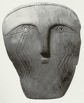
A cut piece of whelk shell, probably a blank for the manufacture of a human maskette (gorget) of the type that appears on the cover of this paper, was dated in a context between 1400 and 1500. The shell gorget was found in an early historic elite burial. This kind of art object was usually the property of sacred chiefs and this may indicate the emergence of chiefdoms in the upper tidewater Potomac. The design on the gorget is known as the weeping eye or thunderbird motif in Mississipian contexts. This may indicate some limited contact and influence of Mississippian societies on the emerging chiefdoms of the Chesapeake's western shore.
After about 1300 a new type of pottery and other artifacts known as the Potomac Creek complex appears at the head of the estuarine Potomac. Potter(1993) and Kavanagh (1982) interpret the abrupt intrusion of these new features as evidence of a migration of corn-planting people coming down the Potomac from the west and north. Potter (1993: 141) identifies the Potomac Creek complex with the historically known Piscataways and the eventual Conoy paramountcy. Potter (1993: sees the Owasco culture from the west and north as the original source of the Potomac Creek (Piscataway) immigrants. This group moved into the Maryland piedmont as early as 900 AD.
Rhyolite Fall-off from Paleoindian to Late Woodland Times
Ideally we would like to know how interaction networks of different kinds (BGNs, PMNs, PGNs and INs) changed over time in terms of extent, intensity and fall-off. It would also be extremely desirable to have DNA evidence to sort out migration and intermarriage patterns. At present we have mainly projectile point types, ceramic types, information about mortuary styles, some indication of settlement numbers and sizes, and indicators of subsistence. The data on these are being increasingly organized into systematic Geographical Information Systems, but there is much to be done to get all the information into a form that can be comparatively analyzed on a multiscalar basis. Here we will use one indicator as a measure of pulsations of trade network expansion and contraction - the fall-off of usage of rhyolite for projectile points. This is not an ideal indicator even for lithic networks because different materials often have different network patterns. What is needed is an analysis of local, regional and long distance exchange networks of different kinds of goods. But for now rhyolite is what we have.
Stewart (1996:82-85) reports a decline in trade volume, but not in extent, during the Early Woodland period from 1000 B.C to 600 B.C and then a trade expansion from 600/500 to 400 B.C.. This was followed by a trade contraction from 400 B.C. to 200 AD. and then another expansion from 200 to 800 AD. In this last expansion there was no sign of cultural influence from the Hopewell heartland despite expanded trade. This was followed by a severe disruption of trade networks during the Late Woodland from 900 AD. on. This was the period of the rise of the Mississippian interaction sphere in the Midwest, and yet neither trade nor cultural influence linked this distant florescence with the Mid-Atlantic region.
Figure 12 shows the transect from the Catoctin to the Patomac and Patuxent drainages and over to the Eastern Shore examined in Stewart's (1984: Table 5) survey of rhyolite fall-off. The percentage of rhyolite propoints in Figure 12 means the relative abundance of projectile points made of rhyolite in the total count of propoints. It does not include debitage or cores. Time is indicated by the propoint types used as period markers.
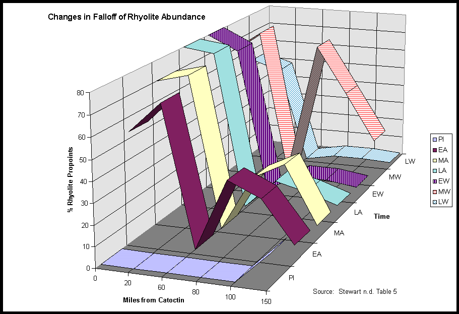
Stewart reviewed site reports and regional overviews
for data on ryolite abundance. One problem indicated in Figure 12 and Table
1 is the consistently low percentage of rhyolite reported for the 60 mile
site, which was Accokeek Creek. This can be seen in Table 1, which contains
the numbers from Stewart's Table 5 that were used in Figure 12.
| Miles from Catoctic | 0 | 20 | 60 | 80 | 100 | 150 |
| Paleoindian | 0 | 0 | 0 | 0 | 0 | 15 |
| Early Archaic | 53 | 68 | 0 | 35 | 28 | 8 |
| Middle Archaic | 70 | 74 | 0 | 27 | 35 | 7 |
| Late Archaic | 80 | 78 | 1 | 16 | 12 | 7 |
| Early Woodland | 80 | 73 | 1 | 9 | 9 | 7 |
| Middle Woodland | 65 | 76 | 2 | 71 | 47 | 23 |
| Late Woodland | 54 | 49 | 0 | 3 | 3 | 2 |
Stewart agrees that the apparent lack of rhyolite at Accokeek Creek may have been due to the failure of the excavators of that site to correctly identify rhyolite projectile points (personal communication). It is unlikely that the people living at Accokeek Creek on the upper tidewater Potomac refused to use rhyolite over ten millennia even while there neighbors on the Patuxent, further away from Catoctin, were using great quantities of it in the Early and Middle Archaic and the Middle Woodland periods. If we ignore Accokeek Creek (60 miles), Figure 12 and Table 1 indicate a pattern of repeated increase and decrease in the use of rhyolite at locations distant from its source.
Consonant with the notion of exotic lithics in the Paleoindian period, 15% of the Paleo points found on the Eastern Shore 150 miles from Catoctin were rhyolite, a rhyolite abundance level that was not seen again until the Middle Woodland period. The Early and Middle Archaic periods show a normal drop-off with distance from the source (ignoring Accokeek Creek), but with rather high usage as far as 100 miles from Catoctin. These were the long-distance exchange networks mentioned above. Late Archaic and Early Woodland show abrupt fall-off and decreased usage. The Middle Woodland shows another expansion of long-distance trade, which then declines again in the Late Woodland period. These alternating periods of trade expansion and contraction are similar to the phenomenon of pulsation found in other world-systems
Kavanagh and Stewart do not believe that the immigrant groups arriving around 900 AD into the Monacacy River valley near the Catoctin were responsible for cutting off the access to rhyolite (personal communication) in the Late Woodland period. The decline in early Late Woodland trade is also seen in other lithic materials from sources distant from the Catoctin. It is possible that local trade of foodstuffs among more specialized producers was increasing while more long range trade was decreasing. Kavanagh says that shell and shell bead trade seems to continue while other kinds of exchange are drying up (personal communication).
The Chesapeake in Comparative and Macroregional Perspective
The comparative world-systems perspective leads us to wonder why the Adena complex expanded from Ohio into the Chesapeake, whereas the Hopewell and Mississippian traditions did not.
The Late Woodland Chesapeake is a significant a mystery from the perspective of the population pressure model of the development of complexity, hierarchy and trade. In the usual conception, greater population density associated with either in situ adoption or immigrant intrusion of maize agriculture (or both) would be accompanied by greater social ranking because more food would make it possible for the elite to devote their time to pursuits other than producing food, and more trade would be needed as a buffer against crop failures. But in the Chesapeake the appearance of maize agriculture is associated with smaller sites, less social hierarchy and less trade. Why? And what might this have to do with the questions raised earlier about Adena influence and the lack of Hopewell and Mississippian influence?
It is quite important to determine whether different developments in the Chesapeake were primarily due to immigration of new groups or rather due to the adoption of new cultural characteristics by indigenous residents. As with the Chesapeake Adena, there are great disputes among archaeologists regarding the advent of e.g. atlatls, bows, pottery, ossuaries and maize. It is possible to distinguish between immigration and local development by looking carefully at archaeological evidence. If pottery or propoint styles change abruptly with no overlap of earlier and later styles or intermediate adaptations, this indicates immigration.
Potter (1993) concludes from the evidence at Patawomeke and Accokeek Creek that the adoption of Potomac Creek pottery in the Late Woodland period was due to the intrusion of groups moving down the Potomac valley from the west. Kavanagh's (1982) study of the Monocacy watershed concurs that waves of immigration are indicated by the advent of Montgomery, Mason Island and Luray complexes. In view of what we see happening in protohistoric times with the Iroquoians moving into the Bay, it should not be surprising that earlier changes may have involved the arrival of new groups.
What is perhaps surprising for the Late Woodland period is that these new arrivals seem to have been more egalitarian and less involved in regional exchange networks than the indigenous residents. It might seem that maize agriculture would be brought by groups devoted to the Mississippian religion in which sacred chiefs mediated between commoners and the powers of the universe. This kind of ideology was found by Captain Smith in the seventeenth century, but it may have been a recent development that accompanied the rise of paramountcies and the late advent of epidemic warfare.
There are two rather different possible explanations for the lack of Mississipian influence in the Chesapeake. One might suppose that a new religion that glorified the elite would not be adopted if a similar religion was already present. It seems unlikely that this was the case in the period in the early Late Woodland when maize agriculturists came in. There is no evidence of hierarchical societies in the Chesapeake in the Middle Woodland period.
A different explanation would paint the immigrants as escapees from Mississippian religion who, because of the productivity of corn agriculture, did not need the long-distance and regional exchange networks that had been a necessary hedge against shortages for the earlier residents. Not needing the ritualized gift-giving and trade meant they could dispense with sacred chiefs. Families of direct producers could get along quite well by storing their own food against hard times because they produced a lot of food. Fagan (1991:383) suggests a similar explanation for the decline of the Hopewell ceremonial complex in the midwest. Well before the arrival of maize in the midwest cultivation of indigenous crops had become so productive that regional exchange relations were less needed. Thus, according to Fagan, the commoners no longer needed their chiefs and could return to a more egalitarian form of organization. Stewart has suggested a similar explanation for the decline of complexity and trade with the coming of maize in the Late Woodland Chesapeake (personal communication). If this is right it constitutes an instance of the circumscription hypothesis's claim that people will run away from hierarchy unless it is the least worst alternative.
Interaction Nets over the Long Run
Rather than a simple model of interaction nets getting larger, we find two complications. The first we have remarked upon before. They get larger and then smaller again, and then once again larger. This is pulsation. But the consideration of nomadism and gradually increasing sedentism changes the overall pattern to some extent. The early Paleoindians were explorers and colonizers of land that was yet uninhabited. They chased big game, but they also tended to concentrate in areas that had greater concentrations of game and other foods (Anderson 1995). As with other colonization sequences, the first arrivals probably took the best locations and then tried to hang on to them. Population density was so low at first that there were plenty of good new locations, and so interaction among groups was mainly friendly. But as the options dried up and the mastodons became scarce, more competition emerged. Some groups developed seasonal migration rounds in particular territories and tried to defend the best camping sites against new arrivals. The small bands always needed to gather with other bands seasonally to trade and exchange marriage partners. But the size of these seasonal gatherings were limited by the availability of food stocks at the meeting place.
Territoriality emerged, but it was probably not well-institutionalized. We do not know whether or not the Paleoindian pioneers brought with them the cultural apparatus of territoriality. The Polynesian pioneers of the Pacific brought with them an ancestral culture that included the concepts of mana an tapu that were the basis of sacred chiefdoms. They probably dispensed with ceremony and hierarchy to become egalitarian foragers when they landed on islands populated by delicious flightless megabirds (e.g. New Zealand). But when the birds were eaten, they reconstructed class societies and territoriality using the linguistic and ideological equipment that was their ancestral culture. Very likely the immigrants to North America did not have such equipment because the Asian societies from whence they came had not yet developed ideas and kin relations appropriate to the symbolization of the linkage between place and blood. This means that the original America pioneers had to invent these things as they came to need them.
The Paleoindian interaction networks were large, especially for exchanging fine and useful objects such as Clovis points and exotic lithic blanks. Cultural styles were widely shared across macroregions. And the territories exploited by human groups were huge, though the numbers of people in each band, and macroband were small. As bands became somewhat less mobile they developed more differentiated tool-kits depending in part on the nature of the territories they inhabited, but also as a way of constructing alliances with friends and differences with foes.
Exchange networks in the Archaic periods exhibited pulsation, and in the midwest a double-movement of localization and cosmopolitanization emerged. Localization, as indicated by the emergence of more and more local distinctive propoint and pottery styles, was cultural differentiation from neighboring peoples. This led eventually to the emergence of elites who's legitimation was based in part on the claim to represent "universal" powers larger than the localized world (Helms 1988). These were the interaction spheres and mortuary religions such as the Adena, Hopewell and Mississippian ideologies. At the same time warfare and the mobilization of labor became more important and the new religions were used to reward brave warriors and to mobilize social labor. Polity sizes grew and hierarchies became steeper. Interaction networks got larger. But these systems regularly overshot their systemic capabilities and collapsed.
Stephen Kowalewski (1995) has proposed the notion that the Eastern United States was a half-continent sized single world-system for ten thousand years, especially understood as an ecological macroregion. Our study of the Chesapeake has begun with the local, and has brought in long-distance processes of trade, diffusion and migration as they have seemed to intrude on local developments. We agree with Kowalewski that the macroperspective is important for understanding what happened on the Chesapeake, but we disagree that the world-system concept should be applied to the entire eastern half of North America. While we agree that environmental factors are important constraints and opportunities for human action, we do not define world-systems as interactions with the environment, but rather as regularized interactions among humans.
It is our contention, then, that the scale of systemic interaction was never at the half-continental level in prehistoric North America. Rather what we had were regional systems that sometimes impacted upon one another, but that were never systemically integrated at the continental or half-continental level. The closest thing to that was the Mississippian world-system, not understood as a religion but as a social, economic and political/military interaction network. And the Mississippian system never included the Mid-Atlantic or New England. The decline of the Mississipian networks in the fifteenth and sixteenth centuries returned eastern North America to a condition of smaller regional systems similar in scale to those that had existed before the rise of the Mississippian system.
In this view the Chesapeake system was never a peripheral region of the central system in the great river valleys of the midcontinent. There were important differentials in settlement size, degree of hierarchy, polity size and etc. But the two areas were never strongly enough integrated by regularized trade and political/military interaction networks to constitute a single system. The closest these two regions came to this was during the Early Woodland period when specialized trade and religious interactions were rather strong. After the demise of the Chesapeake Adena these two regions were again on separate tracks.
This is not to argue that occasional interactions
did not have important effects on the development of the Chesapeake, but
rather to point out that these were conjunctural rather than systemic.
This sort of thing happened several times, in several
places in North America. We sketched this in a diagram depicted such connections
(See Figure 13).
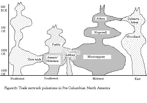
As Figure 13 shows, we see distinct core-periphery systems. We disagree strongly with Kowalewski that interactions and variations are "incremental in space with no consistent or clear boundaries " (Kowalewski 1995: 153). Rather, we argue there are relative densities-which in principle are empirically mapable-that when plotted as contour lines will show regions of sharp fall-off, even while a modicum of continuity persists. Figure 13 is our "best guess" of the distribution of core-periphery systems in North America.
We have argued that world-systems, or core-periphery
systems, have at least four sets of such boundaries, in decreasing size:
information, prestige goods, political/military, and bulk goods. What seems
to happen over large regions-midwest to eastern woodlands-are occasional
linkages at the largest one or two networks, but not at the next smaller
two. We show this possibility in following two figures, taken from Chase-Dunn
and Hall (1997: 60,61):

Figure 14: Schematic representation of 3 isolated
world-systems.
Here we see three separate world-systems or core-periphery
systems that are not in contact. Typically, but now always contact will
be at either information (wavy boundary) or at the prestige/luxury goods
boundary (larger circle). Silent trade would allow prestige goods merger,
without information exchange. Once such contact is made, the situation
might look like this:

Figure 15: 3 world-systems merged at information
and prestige goods exchange boundaries.
Figure 15 shows the same three systems merged at both information and prestige goods exchange level, but not at political/military or bulk goods levels. We might imagine mergers at either only information or only prestige goods levels. This would constitute a larger, multi-cored core-periphery system. This is what, we argue, happened between Adena and Chesapeake but did not happen between Mississippian and Chesapeake.
The earlier merger seems to have been an inversion where some goods - possibly corn - went beyond information in the form of religion, which was rejected. Once people had the seeds, and a bit of knowledge about how to use and to maintain them, they no longer need the religious fol-de-rol that the original bringers may have associated with corn. It may well be, that bringers of corn were fleeing the other system, but brought their corn with them.
Finally, region wide shifts, as Stewart and Kowalewski have noted, may not mean uniform connections and processes. Rather, slight shifts in climate may push local zones over or below corn cultivation thresholds. Similarly, slight to moderate changes in population densities may strain or alleviate stresses on the ecological carrying capacity and hence make hierarchy more, or less, attractive.
The cycling that Anderson (1994) describes so well, clearly indicates that in Michael Mann's apt phrase (1986), "prehistoric people evaded power" whenever they could. The rich estuarine environment in the Chesapeake which supplemented horticulture allowed people to evade it longer. If we imagine the core-periphery systems in Figure 14 somewhat larger, somewhat closer, and "pulsing," we can readily see how various temporary mergers might occur at the outer boundaries. However, when the cycling was downward, that is, when the system contracted, the merger would again be broken. In this case, there is no "cause" of the cessation of trade in the conventional sense of a blockade, interdiction, or whatever. Rather, the normal cycling undermines the fragile merger, allowing a return to more or less autonomy. But if a new technology [corn, or steatite tempered pots] crossed during the merger it might well continue in the absence of continued contact.
Indeed, if the new technology was of the right sort [say corn to supplement volatile hunting] it might actually facilitate downward oscillation or contraction, and "evasion of power." Anderson (1994) argues that evolution from egalitarian to paramount chiefdoms involved long periods of cycling [thousands of years] before it stuck. Under such circumstances, we should expect repeated mergers and disarticulations. This would produce just the types of patterns we sketched for North America, and the puzzling connection-disconnections noted in the greater Chesapeake region.
The trick, in this type of analysis, is to be multiscalar, as Nassaney and Sassaman (1995) argue. To see how these large processes play out in local situations. Under very specific conditions, as we argue below, trade need not be necessary for development of hierarchy. That, that was the case in the Chesapeake need not vitiate the rule of thumb that trade promotes hierarchy.
The failure of the Hopewell and Mississippian traditions to resonate in the Chesapeake is perhaps the most important evidence in favor of our approach over that of Kowalewski. But the somewhat anomalous developments in the Late Woodland Chesapeake also support our approach. Here we have maize agriculture, diffused from the midwest, being adopted by peoples who have not yet developed chiefdoms and in a region that has yet a rather low level of population density relative to the amount of food available for foraging. And, ironically, the adoption of maize raises food productivity to a level where population pressures and chiefdom formation can be put off for several centuries.
In the early historic period we see chiefdom formation getting under way. This is due in part to the rise of population pressure, but another important stimulus is the pressure put on the Chesapeake Algonquians from invading northern Iroquoians. The abandonment of the northwest corner of the Chesapeake must have led to migrations to the south and to the Eastern Shore. And the threat and example of the Iroquois warriors probably encouraged the Algonquians to shift toward a more combative definition of manhood.
Late development of complexity and hierarchy in the Chesapeake was probably related to the incredible fecundity of the land and the bay. This was also an important reason why the peoples of the MidAtlantic could enjoy their autarkic development and egalitarian societies for so long.
Pulsation and Rise and Fall
Did the sequence of pulsation correspond with the rise and fall of hierarchical and large polities, or were there instances in which these cycles occurred independently, or even counter-cyclically? In the Chesapeake we see some developments that seem to go against a simple characterization of trade and hierarchy cycles in phase. But these may be important clues about how evolutionary models might not work at one level of spatial scale, but might work at another.
Table 2 shows roughly how the instances of rise
and fall are related to the pulsations of long-distance trade.
| Period | Dates | Rise and Fall Complexity/Hierarchy | Pulsation of Trade |
| Paleoindian | 9500-8000 BC | Early Macroband Meetings | |
| Early Archaic | 8000-6000 BC | Expand | |
| Middle Archaic | 6000-4000 BC | Middle Atlantic Macroband | Still Expanded |
| Late Archaic | 4000-1000 BC | Contract | |
| Early Woodland | 1000 BC-200 AD | Chesapeake Adena | Still Contracted |
| Middle Woodland | 200-900 AD | Expand | |
| Late Woodland | 900-1550 AD | Fall-line Paramountcies | Contract |
From this it is apparent that there is no regular temporal relationship between these two kinds of sequences in the Chesapeake. Trade expansion in the Early and Middle Archaic is not associated with the emergence of complexity. There is a general increase in population density and more restricted regional nomadism, as well as localization as indicated by regionally differentiated propoint styles. The expansion of long-distance trade may have facilitated these developments, but there are no indications of that tribes had emerged in these periods.
The Chesapeake Adena (500 BC to 1 AD) instance of rise and fall apparently occurred in a period in which long-distance trade was both expanding and contracting. Stewart (1996:82-85) reports that long-distance trade expanded from 600/500 to 400 BC, then contracted from 400 BC to 200 AD. So most of the Chesapeake Adena occurred during a period of trade contraction.
Likewise the final rise of the fall-line paramountcies occurred during a period of relatively little long-distance trade. These patterns do not mean that long-distance interaction is wholly unrelated to hierarchy formation. What would seem to indicated is that that periods of less long distance trade were more likely to support hierarchy formation. It is possible that long distance trade operated to prevent the emergence of hierarchy and complexity. How could this be? Or, alternatively it could be that our temporal considerations have been too crude to catch finer pulsations of trade. In the case of Adena, it looks as though there was an early expansion that could have allowed local groups to import holy goods from Ohio and to develop their own interpretations of the mortuary rituals. The later collapse of the long-distance trade would not have prevented them from circulating these goods on a local basis, as Custer (1984a) claims that they may have done. And possibly the collapse of the trade was due to factors beyond their control, and the inability to contact the Adena homeland did contribute to the eventual abandonment of the rituals.
In the case of the better known fall-line paramountcies, the rather low level of long distance trade did not mean that precious goods from far away were unavailable, but rather that they were scarcer than they had been in Middle Woodland times. The rise of the paramountcies was not hindered by the lack of long distance trade goods in part because these were not primarily prestige goods hierarchies anyway. They were military alliances in which gifts tribute composed of food as well as luxury goods were important, but the ability to cooperate against other enemies was perhaps as important. So the lack of long-distance trade did not either prevent nor facilitate the rise of paramountcies. And it was not the paramountcies that had cut off the trade because the trade collapse had occurred in the early Late Woodland period, whereas the paramountcies did not emerge until centuries later.
Interaction and Evolution in the Chesapeake
Jay Custer's (1986) essay on diversity and evolution in the MidAtlantic region is perhaps the most ambitious effort to summarize what is known about similarities and differences among societies in the Late Woodland period and to provide an explanation of why complexity and hierarchy emerged in some areas but not others. Custer's approach is world-systemic because he includes intersocietal interaction as a main element in his explanation.
Custer's(1986: 162) theory of why hierarchy in the MidAtlantic developed in some areas but not others combines the factors of interaction among groups, the nature of the groups and the adoption of maize agriculture. He contends that once cognatic tribal organization has emerged it is a kind of evolutionary cul de sac in which greater levels of complexity cannot emerge. Thus only segmentary tribes have the possibility of developing class relations and chiefly leadership. He also contends the ecological diversity relative to the kind of subsistence technology being employed is an important part of explaining why hierarchy emerges where it does.
The comparative world-systems perspective would suggest a few refinements here. The most obvious one is that interaction is not a singular phenomenon. There are very different kinds of interaction and they probably have rather different effects on social change or stability. In all of Custer's uses of interaction it promotes the development of complexity and hierarchy. The idea here is that a society that is near to another society with a greater degree of complexity or hierarchy is likely to itself develop complexity and hierarchy as a means of dealing with its neighbor. We know that in some types of systems interaction can lead to devolution, the so-called development of underdevelopment. The other point is that hierarchy-formation is not a one-way process. Hierarchies rise and fall, and this should be explained as well. Custer mentions that apparent decrease in complexity in the early Late Woodland, but he does not explain it.
Nevertheless, Custer's approach has important advantages for explaining what happened on the Chesapeake. He contends that the Powhatan paramountcy may have emerged in large part because of its interactions with more complex groups to the south and west. The idea of course-grained ecology promoting complexity and hierarchy is echoed in Stephen Potter's contention that societies along the border between estuarine and riverine ecologies had a locational advantage for developing hierarchy. Thus both the Conoy and Powhatan paramountcies were in advantageous positions to facilitate a division of labor and to benefit from inter-regional trade.
Our overview of the prehistoric Chesapeake world-systems
points to some questions raised by the comparative world-systems perspective
and we have made a stab at some answers. Our consideration of nomadic
systems and the long-run emergence of sedentism has caused us to revise
our general depiction of the spatial nature of world-systems. The
occasional (non-systemic) interaction between macro-regions sometimes complicates
the evolution of complexity and hierarchy. Inventions such as maize had
rather different consequences for development in the midwest that in the
Chesapeake. Efforts to build a general model of evolution need to
take these sorts of sequences into account.
Arrighi, Giovanni 1994 The Long twentieth Century.
London:Verso
Bastian, Tyler 1975 "New radiocarbon dates for
a Maryland Adena site," Archeological Society of Maryland Newsletter
1,2, (December).
Baugh, Timothy G. and Jonathan E. Ericson (eds.)
Prehistoric Exchange Systems in
North America. New York: Plenum Press.
Caldwell, Joseph R. 1964 "Interaction spheres in prehistory." Hopewellian Studies 12,6:133-156 Springfield,IL.: Illinois State Museum Scientific Papers
Chase-Dunn, Christopher 1998 Global Formation:
Structures of the World-Economy.
Lanham, MD.: Rowman and Littlefield.
Chase-Dunn, Christopher and Thomas D. Hall 1997 Rise and Demise: Comparing World-Systems Boulder, CO.: Westview Press.
______1998 "World-systems in North America: networks, rise and fall and pulsations of trade in stateless systems." American Indian Culture and Research Journal 22:1:23-72.
Chase-Dunn, Christopher, Thomas D. Hall and Susan
Manning. 1998. "Rise and Fall: East-West Synchronicity and Indic Exceptionalism
Reexamined" Forthcoming in Social Science History
Chase-Dunn, Christopher and Kelly M. Mann 1998
The Wintu and Their Neighbors: A Very Small World-System in Northern
California. Tucson: University of Arizona Press.
Chase-Dunn, Christopher and Alice Willard 1993
"Systems of cities and world-
systems: settlement size hierarchies and cycles
of political centralization, 2000 BC-1988AD" A paper presented at the International
Studies Association meeting, March 24-27,
1993, Acapulco. http://www.jhu.edu:80/~soc/pcid/papers/17/pcidpap17.htm
Clark, Wayne E. And Helen C. Rountree 1993 "The Powhatans and the Maryland Mainland," Pp. 112-135 in Rountree (ed.) 1993a.
Collings, Frances d'A. 1988 The Discovery of the Chesapeake Bay: An Account of the Explorations of Captain John Smith in the Year 1608. St. Michaels, MD.: Chesapeake Bay Museum.
Collins, Randall 1992 "The geographical and economic world-systems of kinship-based and agrarian-coercive societies." Review 15,3:373-88 (Summer).
Curry, Dennis 1999 Feast of the Dead: aboriginal ossuaries in Maryland Maryland Historical Trust.
Curry, Dennis C. And Maureen Kavanagh 1991 "The Middle to Late Woodland Transition in Maryland," North American Archaeologist 12,1:3-28.
Custer, Jay F. 1984 Delaware Prehistoric Archaeology:
An Ecological Approach. Newark: University of Delaware Press.
_______ 1986 "Late Woodland cultural diversity
in the Middle Atlantic: an
evolutionary perspective," Pp. 143-168 in Jay
F. Custer (ed.) Late Woodland
Cultures of the Middle Atlantic Region.
Newark: University of Delaware Press.
Davidson, Thomas E. 1993 "Relations between Powhatan and the Eastern Shore," Pp. 136-153 in Rountree (ed.) 1993a.
Dragoo, Don W. 1963 Mounds for the Dean: An analysis of the Adena Culture. Pittsburgh: Annals of the Carnegie Museum Vol. 37.
Dincauze, Dena F. And Robert J. Hasensstab 1989 "Explaining the Iroquois: tribalization on a prehistoric periphery" Pp. 67-87 in Timothy C. Champion (ed.) Centre and Periphery: Comparative Studies in Archaeology London: Unwin Hyman.
Dunaway, Wilma. 1994. "The Southern Fur Trade and the Incorporation of Southern Appalachia into the World-Economy, 1690-1763." Review 18:2(Spring):215-242.
Ebright, Carol A. 1992 Early Native American Prehistory on the Maryland Western Shore: Archeological Investigations at the Higgins Site. Prepared for Maryland State Railroad Administration by the maryland State Highway Administration and Maryland Geological Survey, Department of Natural Resources. State Highway Administration Archeological report #1.
Egloff, Keith and Deborah Woodward 1992 First People: The Early Indians of Virginia, Charlottesville: University of Virginia Press.
Ekholm, Kasja and Jonathan Friedman. 1980. "Toward
a Global Anthropology." Pp. 61-76 in History and Underdevelopment,
edited by L. Blusse, H. L. Wesseling and G. D. Winius Leyden: Center for
the History of European Expansion, Leyden University.
_____. 1982. "'Capital' Imperialism and Exploitation
in the Ancient World-systems." Review 6:1(Summer):87-110.
Ericson, Jonathan and Timothy Baugh (eds.) 1993 The American Southwest and Mesoamerica: Systems of Prehistoric Change. New York: Plenum.
Fagan, Brian M. 1991 Ancient North America. London: Thames and Hudson.
Ferguson, Alice L, and Henry G. 1960 Piscataway Indians of Southern Maryland. Accokeek, MD: Alice Ferguson Foundation.
Ferguson, R. Brian and Neil L. Whitehead (eds.) 1992 War In the Tribal Zone: Expanding States and Indigenous Warfare. Santa Fe. N.M.: School of American Research Press.
Ford, T. L. 1976 "Adena sites on the Chesapeake Bay," Archaeology of Eastern North America 4:63-89.
Frank, Andre Gunder and Barry Gills (eds.) 1993 The World System: Five Hundred or Five Thousand Years? London. Routledge.
Friedman, Jonathan 1992 "General Historical and
Culturally Specific Properties of Global Systems." Review 15:3:
335-72.
Friedman, Jonathan and Michael Rowlands. 1977.
"Notes Towards an Epigenetic Model of the Evolution of 'Civilization'."
Pp. 201-278 in The Evolution of Social Systems, edited
by J. Friedman and M. J. Rowlands. London: Duckworth (also published in
same title and pages, University of Pittsburgh Press, Pittsburgh, 1978).
Galloway, Patrica (ed.) 1989 The Southeaster
Ceremonial Complex: Artifacts and
Analysis. Lincoln: University of Nebraska
Press.
Hall, Thomas D. 1986. "Incorporation into the
World-system: Toward a Critique." American Sociological Review 51:3(June):390-402.
_____. 1989. Social Change in the Southwest,
1350-1880. Lawrence: University Press of Kansas.
______1991 "The role of nomads in core/periphery
relations," Chapter 7 in C. Chase- Dunn and T. D. Hall, Core/Periphery
Relations in Precapitalist Worlds. Boulder, CO.: Westview.
Hall, Thomas D. and Christopher Chase-Dunn. 1993. "The World-Systems Perspective and Archaeology: Forward into the Past." Journal of Archaeological Research 1:2:121-143.
Hantman, Jeffrey L. 1990 "Between Powhatan and Quirank: reconstructing Monacan
culture and history in the context of Jamestown," American Anthropologist 92,3:676-90.
______1993 "Powhatan's relations with the Piedmont Monacans" Pp. 94-111 in Rountree (ed.) 1993a.
Helms, Mary W. 1988 Ulysses' Sail: An Ethnographic Odyssey of Power, Knowledge, and Geographical Distance. Princeton: Princeton University Press.
Kavanagh, Maureen 1982 Archaeological Resources
of the Monocacy River Region.
Maryland Geological Survey, Division of Archaeology,
File Report #164.
Kowalewski, Stephen A. 1995 "Large scale ecology
in aboriginal Eastern North
America," Pp 147-173 in Nassaney and Sassaman.
King, Adam and Jennifer A. Freer 1995 "The Mississippian
Southeast: a World-
systems Perspective," Pp 266-289 in Nassaney
and Sassaman.
Kirch, Patrick 1984 The Evolution of Polynesian Chiefdoms. Cambridge. Cambridge University Press.
Luckenbach, Alvin H. Wayne E. Clark and Richard
Levy 1987 "Rethinking cultural
stability in Eastern North American prehistory:
linguistic evidence from Eastern Algonquian." Journal of Middle Atlantic
Archaeology 3:1-33.
Mann, Barbara A. And Jerry L. Fields 1997 "A Sign in the Sky: Dating League of the Haudenosaunee." American Indian Culture and Research Journal 21,2:105-64.
Mouer, L. Daniel 1986 "DMZ or deer park? Buffer zones as boundary sysstems." Ms. on file, Virginia Department of Historic Resources, Richmond.
Nassaney, Michael S. And Kenneth E. Sassaman (eds.) 1995 Native American Interactions: Multiscalar Analyses and Interpretations in the Eastern Woodlands. Knoxville: University of Tennessee press.
Pendergast, James F. 1991 "The Massawomeck: Raiders and Traders into the Chesapeake Bay in the Seventeenth Century" Transactions of American Philosophical Society, Vol. 81, Part 2. Philadelphia, PA.: The American Philosophical Society.
Peregrine, Peter 1996 "Hyperopia or hyperbole?:
The Mississippian World-System," Pp.39-50
in Peter Peregrine and Gary M. Feinman (eds.) Pre-Columbian World Systems.
Madison, WI.: Prehistory Press
Peregrine, Peter N. And Gary M. Feinman (eds.)
1996 Pre-Columbian World Systems. Madison, WI.: Prehistory Press.
Potter, Stephen R. 1993 Commoners, Tribute and Chiefs: The development of Algonquian culture in the Potomac Valley. Charlottesville: University of Virginia Press.
Renfrew, Colin 1987 Archaeology and Language:
The Puzzle of IndoEuropean
Origins. London: Jonathan Cape.
Rountree, Helen C. 1989 The Powhatan Indians
of Virginia: Their Traditional Culture. Norman, OK.: University of
Oklahoma Press.
______1990 Pocahontas's People: the
Powhatan Indians of Virginia Through Four Centuries. Norman, OK.: University
of Oklahoma Press.
______1993a (ed.) Powhatan Foreign Relations,
1500-1722 Charlottesville: University of Virginia Press.
______1993b "The Powhatans and other Woodland Indians as Travelers," Pp. 21-52 in Rountree (ed.) 1993a
______1993c "Summary and Implications." Pp. 206-228 in Rountree (ed.) 1993a.
Rountree, Helen C. And Thomas E. Davidson 1997 Eastern Shore Indians of Virginia and Maryland. Charlottesville: University of Virginia Press.
Sassaman, Kenneth E. 1995 "The cultural diversity
of interactions among Mid-
Holicene societies of the American Southeast,"
Pp. 174-204 in Nassaney and
Sassaman.
Schmitt, Karl Jr. 1965 "Patawomeke: an historic Algonkian site," Quarterly Bulletin, Archeological Society of Virginia 20,1:1-36.
Shannon, Thomas R. 1989 An Introduction to the World-Systems Perspective Boulder, CO.:Westview.
Smith, Bruce D. 1992 Rivers of Change: Essays on Early Agriculture in Eastern North America. Washington: Smithsonian.
Stephenson, Robert L. The Prehistoric People of Accokeek Creek. Accokeek, MD. Alice Ferguson Foundation.
Steponaitis, Laurie C. 1983 An Archaeological Study of the Patuxent Drainage. Vol. 1. Maryland Historical Trust Manuscript Series #34.
Stewart, R. Michael 1984. "South Mountain (meta) rhyolite: a perspective on prehistoric trade and exchange in the Middle Atlantic Region," in Jay F. Custer (ed.) Prehistoric lithic exchange systems in the Middle Atlantic Region, University of Delaware Center for Archaeological Research, Monograph #3.
______1994 "Late Archaic through Late Woodland
exchange in the Middle Atlantic region." Pp. 73-97 in Baugh and Ericson.
_______1999 "Changing patterns of native trade in the prehistoric
Middle Atlantic region," A paper presented at the annual meetings of the
International Studies Association, Washington, DC, February 1999.
Turner, E. Randolph III 1978 "An intertribal deer exploitation buffer zone for the Virginia Coastal Plain-Piedmont regions," Archeological Society of Virginia, Quarterly Bulletin 32,3.
______1993 "Native American protohistoric interactions in the Powhatan core area," Pp. 76-93 in Rountree (ed.) 1993a.
Upham, Stedman. 1992. "Interaction and Isolation: The Empty Spaces in Panregional Political and Economic Systems." Pp 139-152 in Resources, Power, and Interregional Interaction, edited by Edward Schortman and Patricia Urban. New York: Plenum Press.
Wallerstein, Immanuel 1974 The Modern World-System, Vol.l. New York: Academic Press.
Wood, Peter H. Gregory A. Waselkov and M. Thomas Hatley (eds.) 1989 Powhatan's Mantle: Indians in the Colonial Southeast. Lincoln: University of Nebraska Press.
Wilkinson, David 1987 "Central civilization" Comparative
Civilizations Review 17:31- 59.
_____. 1991. "Cores, Peripheries and Civilizations."
Pp. 113-166 in Core/Periphery Relations in Precapitalist
Worlds, edited by Christopher Chase-Dunn and Thomas D. Hall. Boulder,
CO: Westview Press.
_____. 1995a. "Central Civilization." Pp. 32-60
in Civilizations and World-Systems: Two Approaches to the Study of World-Historical
Change, edited by Stephen K. Sanderson. Walnut Creek, CA: Altamira
Press.